South Mountain Reservation is home to a complex network of trails, including the Orange Reservoir Loop.
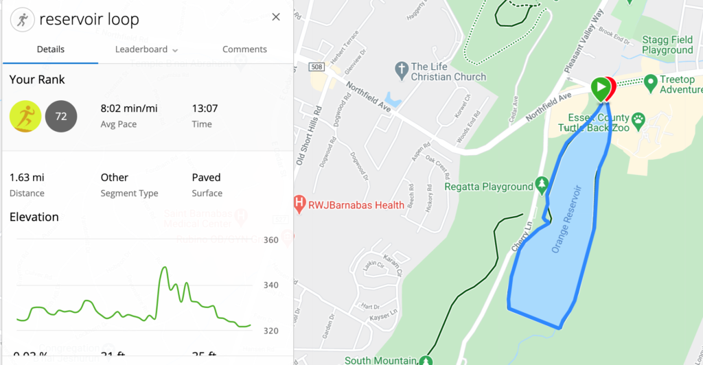
The Orange Reservoir Loop is a paved trail that loops around the Orange Reservoir in the northern part of South Mountain Reservation. It’s approximately 1.6 miles long, and it has distance markers every 1/10 of a mile.
The loop is a great place to run if you’re looking for a natural setting with easy terrain. There is easy access to multiple trails if you want something more adventurous. The distance markers also make this a great place to run interval workouts.
Let’s explore the Orange Reservoir Loop.
Accessing the Orange Reservoir Loop
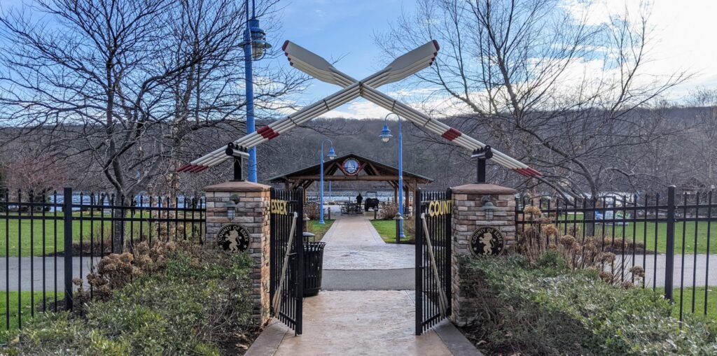
The most common way to access the Orange Reservoir Loop is from the parking lot across Cherry Lane, near the Regatta Playground (see on Google Maps). From there, you can cross the street at the traffic light and enter through the gates.
You’ll end up in the loop near the dock on the west side.
There are several other ways to access the loop, though.
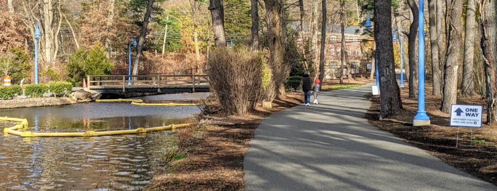
If you’re on foot, there are two gates at the north end along Northfield Ave. This is how I get there, since I jog over from my house.
You can also park in the parking lot at McLoone’s Boathouse. From there, there’s a walking path that puts you on the northwest side of the reservoir near the “starting point” of the distance markers.
If you are at the Zoo, or if you park in the Zoo parking deck, there’s a path connecting to the northeastern side of the reservoir.
And if you’re in the trail network, you can take the Reservoir Trail (from the south) or the Zoo Loop (from the north). The Zoo Loop exits the forest and joins with the Orange Reservoir Loop in the southeastern corner of the reservoir.
Exploring the Orange Reservoir Loop
Let’s assume that you enter the Orange Reservoir Loop from the parking lot on Cherry Lane.
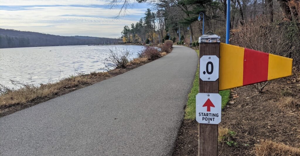
The official “starting point” is to your left. That’s where you see the post marked “.0” which denotes the beginning of the loop.
However, the loop is currently one way, counter clockwise, to promote social distancing. So we’ll turn to the right and proceed south.
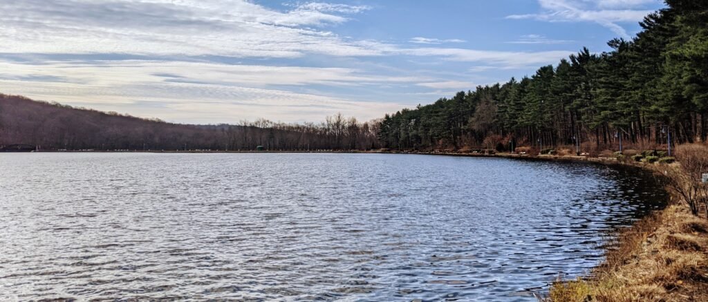
The reservoir widens out here a little bit and the path will curve to the right slightly. From here, you can clearly see across the reservoir to the straight away on the southern end.

When you get to the southern end, the path will turn sharply left. From here, there’s a straight away about 2/10 of a mile long.
This is a great place to do strides or short sprints. It’s perfectly flat. The distance between two markers – 1/10 of a mile – is about 160 meters.
At the end of the straight away, there’s a bridge. If you look to the right, you may see a small waterfall as water exits the reservoir and joins with a stream.

After the bridge, the loop turns sharply to the left. There’s a small hill here. It’s only about 20 feet of elevation gain, but it’s the only perceptible elevation gain on the whole loop.
Continuing along the path, you’ll soon spot some concrete steps off to the side. These steps lead up the hill, and you can turn left to take the Zoo Loop or turn right to take the Reservoir Trail towards the Lenape Trail.
The Zoo Loop actually joins with the Orange Reservoir Loop here, and they travel together until the northern end of the reservoir.
Continue north, along the east side of the reservoir. You’ll see a train track on your right. This is the little train ride that you can take at the zoo when the weather is nice.
You’ll also pass the entrance to the zoo complex on your right. During the summer, the zoo parking lots fill up. The parking lots on Cherry Lane are used for overflow parking, and people walk around the reservoir to get into the zoo here.
At the north end, you’ll see a wooden bridge. You can either take this across the reservoir to continue around the loop, or you can continue straight a short bit further to Northfield Ave and turn left there.
I think the “official” route goes up to Northfield Ave and around to the left, based on the distance markers. But I usually take the wooden bridge and loop around there. If you take this turn, it’s approximately 1.65 miles around the loop. If you go to Northfield Ave, it’s closer to 1.75 miles.
Once you loop around, you’ll travel south along the western side of the reservoir.
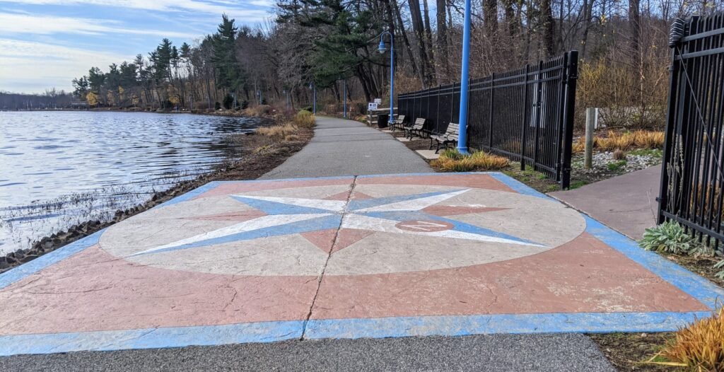
There’s a square design in the middle of the path that looks like a compass. The walking path that leads to the right will take you to the parking lot outside McLoone’s boathouse.
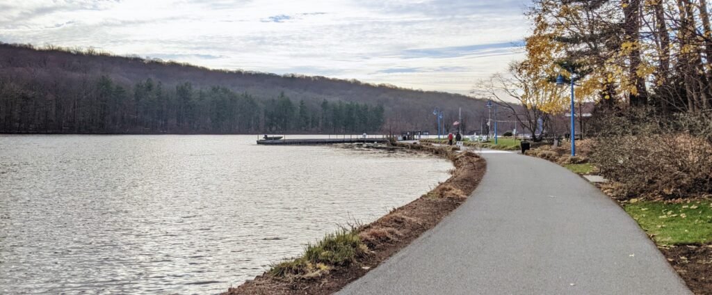
After you pass the path to McLoone’s, you’ll go past the marked starting point of the loop.
From there, you can see the dock jutting out into the middle of the reservoir. This dock is next to the pavilion where you entered.
And that’s a full loop!
Final Thoughts on the Orange Reservoir Loop
The Orange Reservoir Loop is a great place to run, walk, or walk your dog. It’s one of my favorite parts of the South Mountain Reservation, and before I started fully exploring the trails I spent a lot of time here.
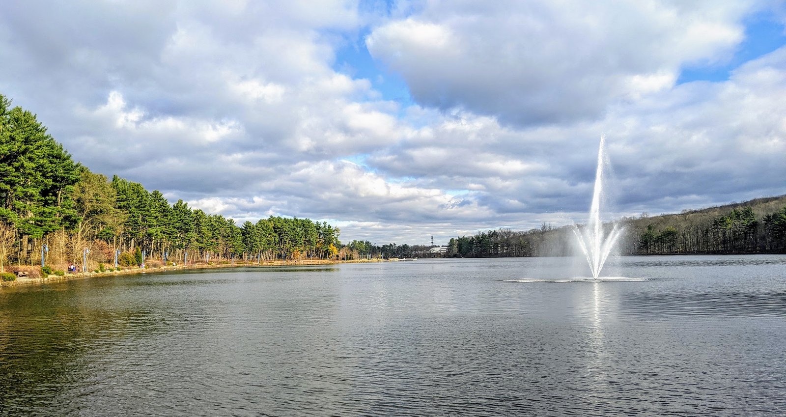
The ambiance is great. There’s a nice view of the water, and there’s a certain smell, too. When the fountains are running, there’s a light mist that comes off the reservoir that can be quite refreshing.
This is a great place to run a workout. It’s flat, so you don’t have to worry about elevation changes. The distance markers help when running short sprints, too. It’s a little short for a long run, though. I’m usually good for 2-3 loops, but I’d had to run around this loop 7 or 8 times.
I often run here in the morning. The sun will shine on the west side of the loop, but the east side will be in the shade. Be aware that this can make quite a difference in the temperature on a cold day.
I’d also caution you that the Orange Reservoir Loop can be quite popular on weekends and when the weather is nice. I rarely see big crowds on weekday mornings, when I’m running. However, summer weekends can be jam packed with people.
In normal times, this can be an inconvenience that slows down your run, but these days you may be even more cautious of crowds. I personally avoid the loop on weekends, although during the winter I’ll probably check it out. When it’s cold, there’s usually not as many people walking.
Check out this collection of trails in the South Mountain Reservation for other running trails to try out.
And if you’re interested in trail running, check out this guide to the what, how, and why of trail running.
I’m curious what you think about it. Have you run around the Orange Reservoir Loop?
What did you think about it? Leave a comment below.